
TRENTON — The Department of Environmental Protection announced April 3 the launch of an informational website and mapping tool to help the public, stakeholders and government officials advance work to make coastal wetlands more resilient to increasing rates of sea-level rise, which in New Jersey are twice the global average.
Data derived from the development of the tool shows that 61 percent of the state’s coastal wetlands may be at risk of being lost because the processes that help create them are not able to keep pace with the accelerating pace of sea-level rise. This situation potentially jeopardizes the ecological diversity that is found in robust wetlands as well as the important storm-surge protection wetlands provide coastal communities.
“The Murphy Administration is committed to advancing strong science as part of its comprehensive approach to making the state more resilient to the many impacts of climate change,” Environmental Protection Commissioner Shawn M. LaTourette said. “By pinpointing areas where sea-level rise is having the most profound localized impacts on tidal wetlands, this tool will
improve local decision-making on wetlands restoration and enhancement projects that will better protect natural resources and coastal communities.”
“The science clearly demonstrates that our coastal wetlands are facing increased stress due to the accelerating pace of sea-level rise,” New Jersey Chief Resilience Officer Nick Angarone said. “This tool, developed with our many partners in the New Jersey Tidal Wetland Monitoring Network, builds upon the many planning and technical resources the DEP provides to help communities make informed decisions about climate resilience and plan for the impacts and the associated hazards of climate change.”
“Elevation changes are the most fundamental component of tidal wetland resilienc,” said LeeAnn Haaf, Estuary Science Assistant Director for the Partnership for the Delaware Estuary. “This new website and mapping tool are aimed at answering the question: Is marsh elevation keeping pace with sea-level rise?”
Importance of coastal wetlands
New Jersey has about 200,000 acres of coastal wetlands that support diverse and ecologically sensitive ecosystems. These wetlands also help buffer coastal communities from the potentially devastating impacts of storms.
New Jersey’s relative sea levels, however, are rising at a rate that is about twice the global average due to the effects of climate change caused by greenhouse gas emissions.
Under a moderate greenhouse gas emissions scenario, New Jersey is projected to experience a likely range of 2 to 5 feet of sea-level rise by 2100.
Coastal wetlands respond differently to sea-level rise due to a variety of factors, including local topography, water flow and currents, and the rate of sea-level rise. Moreover, there can be significant variability in localized wetland impacts.
Tidal wetlands can naturally gain elevation through sediment and organic deposition during tide cycles and flooded conditions. In many parts of New Jersey, however, wetlands are not gaining elevation at a rate that equals or exceeds local rates of sea-level rise.
When wetland surfaces do not keep pace with sea-level rise rates, high marsh may convert to low-marsh and low-marsh to mud flats or open water.
This results in a loss of valuable habitat for many year-round and migratory birds and fish, lost recreational and economic losses for commercial and recreational fisheries, and loss of natural flood and storm-surge protection for communities and infrastructure.
Murphy administration responds
In 2018, the administration of Gov. Phil Murphy formed the New Jersey Tidal Wetland Monitoring Network to track current conditions and trends relative to tidal wetlands to improve the resilience of coastal communities and ecosystems. Led by
science and research staff at the DEP, the network is comprised of more than 15 research organizations, universities and non-profits.
Data the network develops support informed wetland restoration and protection management efforts.
In developing the new website and tool, the network used long-term monitoring datasets to make more accurate assessments of how New Jersey’s coastal wetlands are responding to accelerating rates of sea-level rise.
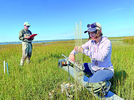
The network measured marsh elevation change and sedimentation rates at Surface Elevation Table (SET) stations throughout the state.
At each SET station, the marsh-elevation change rate was compared to long-term and recent sea-level rise rates from the nearest National Oceanic and Atmospheric Administration (NOAA) National Water Level Observation Network station.
The research demonstrated that long-term sea-level rise rates ranged from 3.2 to 5.1 millimeters per year, with more recent subsets of the data showing that the rate of sea-level rise has accelerated in recent decades, ranging from 4.3 to 6.7 millimeters per year.
Thirty-nine percent of the stations analyzed experienced elevation change rates higher than the recent rate of sea-level rise, indicating that 61 percent of the stations and, therefore, the surrounding wetlands, are potentially vulnerable to losses from increased rates of sea-level rise.
Potentially vulnerable tidal wetland sites can be found along the ocean (including Sandy Hook, Forked River, Island Beach, parts of Barnegat and Great bays and Stone Harbor, among others), as well as along the tidal Delaware Estuary from Delaware Bay (including Dennis Creek, Dividing Creek and parts of Stow Creek), and along the Delaware River to Trenton.
Practical applications
The results are displayed on an interactive map, which summarizes long-term monitoring data from a wide range of sites. These sites vary across several aspects such as tide range, salinity and disturbance level.
The new interactive map and data can be used with other tidal wetland restoration tools and datasets, such as the New Jersey Restoration Organization Suite (NJ ResTOrs), which includes six additional restoration tools to help stakeholders plan restoration activities.
A database developed as part of this project provides an organized collection of monitoring data that allows the network to store, retrieve, update and manage its data efficiently. In addition to elevation and sea-level rise rates, other wetland metrics contained in the database include vertical sediment accumulation rates, shallow marsh subsidence rates and vegetation type information.
Visit the Division of Science and Research’s Wetlands Research website for more information on other DEP wetlands research efforts.