
CAPE MAY COURT HOUSE — Office of Emergency Management Director Chris Leusner presented an update on the county’s official evacuation zones Dec. 16 to the Cape May County Board of Commissioners.
Leusner outlined how the zones were developed, how they align with state and federal planning requirements and how they will be used to guide evacuation decisions and public messaging during major storm events.
He explained that the purpose of the update was to provide the board with a clear understanding of the countywide evacuation zones, and to demonstrate how those zones will appear and function on the county’s evacuation map.
State law requires coastal county evacuation and sheltering plans be coordinated regionally and fully integrated into the New Jersey State Emergency Operations Plan. Under New Jersey statutes, Cape May County must align its evacuation planning with statewide strategies to ensure a synchronized response and efficient use of limited resources such as roadways, shelters, transportation assets and public safety personnel during large-scale emergencies.
The evacuation zones satisfy those requirements while providing a clear, uniform framework that municipalities can incorporate into local plans, ordinances, public information efforts and emergency exercises, Leusner said.
The analysis also considered multi-hazard risks, evacuation demand from neighboring counties, designated shelter locations and real-world traffic flow on the region’s transportation network. As a result, the zones adopted by the county mirror the zones used by state decision-makers when evaluating storm tracks, timing and evacuation recommendations.
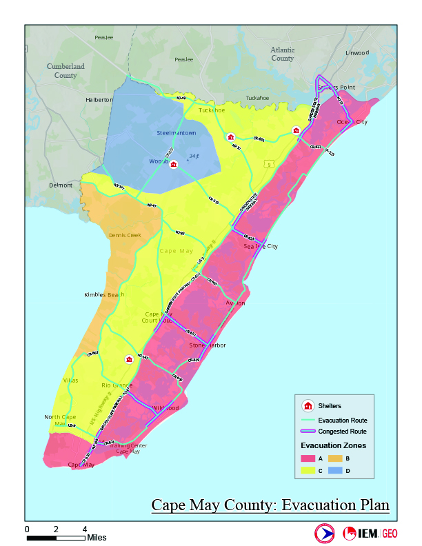
The evacuation map is organized into four primary zones:
— Zone A includes the barrier island and oceanfront communities most vulnerable to early and severe storm surge, such as Ocean City, Sea Isle City, Avalon, Stone Harbor, the Wildwoods, Cape May City, West Cape May and Cape May Point.
These areas represent the first tier for mandatory evacuation during serious storm threats due to life-threatening surge risk and potential isolation from causeway closures.
— Zone B encompasses the 100-year storm surge areas, primarily bayside communities in parts of Lower, Middle and Dennis townships, that may experience significant flooding during stronger or prolonged events.
— Zone C covers extended coastal and inland flood hazard areas across portions of Lower, Middle, Dennis and Upper townships, where access and infrastructure may be affected during extreme storms.
— Zone D includes Woodbine Borough and portions of Dennis Township that face comparatively lower surge risk but may still be affected during the most severe events and may serve as sheltering or reception areas depending on state guidance.
Adopting the evacuation zones enhances public preparedness by giving residents, visitors and businesses a simple way to understand their evacuation status and what actions may be required, according to a news release from the county.
The county plans to support the rollout with a dedicated “Know Your Zone” resource on its website, allowing users to quickly identify their zone and understand evacuation guidance well before a storm threatens.
“These evacuation zones give us a clear, consistent framework that aligns local decision-making with state and federal planning tools,” Leusner said. “When residents know their zone ahead of time, they are far better prepared to act quickly and safely when evacuation guidance is issued.”
Board of Commissioners Director Leonard Desiderio emphasized the importance of clarity and coordination in emergency planning.
“Public safety depends on preparation and communication,” he said. “By adopting these standardized evacuation zones, Cape May County is strengthening its ability to protect residents and visitors while ensuring our response is fully coordinated with state agencies during major storm events.”